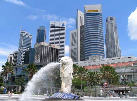
History of Urban
Planning in Singapore
Urban
planning in Singapore has its beginnings in the 1820s, when Sir Stamford
Raffles implemented a land-use plan later known as the Raffles Town Plan.
However, for most of the 19th century and the first half of the 20th century,
Singapore's physical growth was haphazard and largely unregulated. It was only
in the mid-1950s that Singapore truly began its journey towards the planned
city-state that the world sees today. Urban planning is currently undertaken
within a comprehensive framework comprising two key plans: the concept plan,
which is the macro-level blueprint, and the statutory master plan, which
translates the vision of the concept plan into detailed guidelines.
Under British Rule
In 1822, Raffles initiated a comprehensive town plan to guide the
allocation of land in the principal town to ensure that its physical growth
followed an orderly pattern. This became known as the Raffles Town Plan. Among
its key features were a grid layout for the road network and a clear
segregation of residential communities by ethnic group (European, Chinese,
Indian, Malay and Arab). A separate area called Commercial Square was
designated for commercial activities and another area was zoned for government
functions. Raffles Place, which was formerly Commercial Square, and the street
pattern of the city centre today are evidence of this colonial legacy.
However, the Raffles Town Plan guided the city's growth for less than a decade.
By the early 1900s, the city area had become severely overcrowded. In the
absence of an updated town plan and with the lack of control by the British
government, slums had sprung up in the older sectors of the city and in the
outlying areas. The roads had also become congested, unable to cope with the growth
of motor transport. To alleviate these problems, the Singapore Improvement
Trust (SIT) was set up in 1920 and constituted as a legal entity in 1927 with
the enactment of the Singapore Improvement Ordinance. But by the time it was
dissolved in 1959, SIT had achieved very little. It had built only 23,000
housing units, far from adequate to meet the needs of the burgeoning
population, and it had carried out only limited improvement works such as
widening of roads. It had neither the power to undertake overall physical
planning nor the power to control development, until 1951.
In 1951, following an amendment to the Singapore Improvement Ordinance, the SIT
was tasked with conducting an islandwide diagnostic survey of Singapore
and subsequently preparing a master plan to guide its physical growth. The
statutory master plan was completed in 1955 and approved in 1958. A predecessor
of the current master plan, it regulated the type and intensity of development
by specifying the land-use zoning and the maximum density or plot ratio for
each site. It also reserved land for infrastructural uses, community facilities
and open spaces.
 | After Self-Government (First Concept Plan)
In
1959, the British government enacted the Planning Ordinance to replace the
Singapore Improvement Ordinance. The new law took effect in February 1960,
simultaneously dissolving the SIT and creating the Planning Department within
the Prime Minister's Office to take on the role of central planning authority.
By then, Singapore was a self-governing state. The Planning Department was
given the power to control the development of land throughout Singapore for the
purpose of implementing the 1958 master plan. It also had the power to review
and amend the master plan once every five years.
However, the government soon realized that the planning strategies embodied in
the master plan would be inadequate to cope with the rapid social and economic
changes taking place in Singapore. It therefore sought the help of the United
Nations (UN) to formulate a long-term framework for urban development in
Singapore. UN representatives visited Singapore in 1962 and 1963 and their
recommendations eventually led to the launch of the State and City Planning
Project (SCP) in 1967. For the government, land-use planning then had to
address the two priorities of a newly independent Singapore: the provision of
adequate housing and the generation of employment opportunities for the people.
Assisted by the UN, the government completed the SCP in 1971 and the result was
Singapore's first concept plan, a long-range plan to guide the country's
physical development for the next 20 years. Unlike the master plan, which
provided detailed zoning and density parameters, the concept plan showed only
the broad direction of the government's land allocation and transportation
policy. Another key difference was that the concept plan was not a statutory
document, though most of its proposals were implemented.
The concept plan envisaged the development of high- and low-density residential
estates, industrial areas and commercial centres in a ring formation around the
central water catchment area, as well as a network of expressways and a mass
rapid transit (MRT) system to provide islandwide interconnectivity.
Safeguarding land for the expressway and MRT networks early on meant fewer
planning problems and less disruption to the public when construction actually
began. Similarly, the concept plan set aside land for the Changi Airport. The
first expressway, Pan Island Expressway, and the Changi Airport Terminal 1 were
completed in 1981 and the MRT network was opened in 1987.
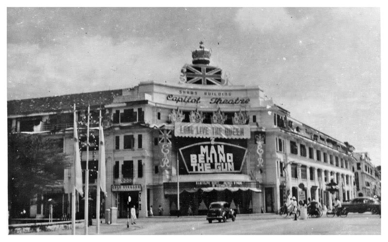
 Source: Old Singapore (Above an old street of Singapore, Bottom the Old Capitol Teater)
 Revisions of Concept
Plan and Master Plan
Between 1971 and 1991, the master plan was revised five times - in 1965, 1970,
1975, 1980 and 1985. After the 1991 concept plan was completed, the government
embarked on a major review of the 1985 master plan. This involved a more
forward-looking approach compared to the previous reviews, which were mainly
updating exercises. In the process, 55 development guide plans were drawn up
between 1993 and 1998, and these formed the final 1998 master plan.
Another review of the concept plan was completed in 2001 and its broad
strategies were translated into the 2003 master plan. Building on the preceding
plan, the 2001 concept plan aims to make Singapore a "thriving world-class
city". Although the plan was originally scheduled to be reviewed after ten
years, a mid-term review was conducted in 2006 and the resulting proposals were
incorporated into the latest master plan released in 2008. The government began
work on the next concept plan in 2009 and the revised blueprint will be completed
by 2011.
|